
References: Customized information systems with advangeo® | |||
| 2010 | Ghana |
Mineral exploration targeting for gold in NW-Ghana using artificial intelligence and GIS with advangeo® Prediction Software Client: BRGM, European Union |
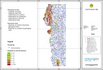 |
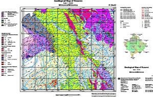
| 2004-2008 | Kosovo |
Planning and creation of nationwide geo-scientific maps of Kosovo in the sub-steps: developing the map concepts, creation of legends, data processing and data homogenization, data collection, cartography. The following maps are part of the project: geological maps, hydro-geological map, tectonic map, soil map, minerals map, resource management map, thermal and mineral waters map. Client: Independent Commission for Mines and Minerals of Kosovo |
 |
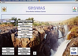
| 2005-2006 | Republic of South Africa |
Planning, implementation and introduction of a customised database and GIS as an absolute prerequisite for the rehabilitation activities at the Witwatersrand Mining Basin that is marked by a high density of mines, mining waste facilities and enormous environmental problems. Client: Council for Geosciences South Africa |
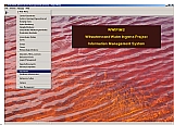 |
| 2004-2005 | Namibia |
Planning and implementation of the geo-scientific information system for the Department of Water Affairs of the Ministry of Agriculture, Water Affairs and Rural Development of Namibia. Client: Ministry of Agriculture, Water and Forestry |
 |
| 2004 | Kosovo |
Development of the Geo-Database Kosovo. Client: Independent Commission for Mines and Minerals (ICMM), Prishtina |
 |
| Page: Item: 6 - 10 Total: 10 |